
Classical Studies
Maps
Find maps of the classical world in the following print and digital resources:
-
 The Atlas of Ancient Rome
by
Call Number: Ref DG63 .A8513 2017A comprehensive archaeological survey of the city of Rome from prehistory to the early medieval period.
The Atlas of Ancient Rome
by
Call Number: Ref DG63 .A8513 2017A comprehensive archaeological survey of the city of Rome from prehistory to the early medieval period. -
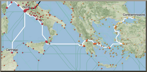 ORBIS: the Stanford Geospatial Network Model of the Ancient World
website
ORBIS: the Stanford Geospatial Network Model of the Ancient World
website
Reconstructs the time cost and financial expense associated with a wide range of different types of travel in antiquity. The model is based on a simplified version of the giant network of cities, roads, rivers and sea lanes that framed movement across the Roman Empire. Developed by Stanford University. -
 Pleiades
website
Pleiades
website
A community-built gazetteer and graph of ancient places. It publishes authoritative information about ancient places and spaces, providing unique services for finding, displaying, and reusing that information under open license. -
 Ancient World Mapping Center
website
Ancient World Mapping Center
website
Hosts a series of downloadable maps that are freely available for educational use and also can be licensed for publication at nominal cost. The maps are organized according to rough geographic regions, including the Roman Empire, the Iberian Peninsula, Egypt, the Aegean, and the Mediterranean. -
 Atlas of the Greek World
by
Call Number: Atlas DF77 .L43 1984Text, illustrations and maps describe the history of Greece from ca. 3000 B.C. to 500 A.D. Glossary, gazetteer and bibliography are at the end of the volume.
Atlas of the Greek World
by
Call Number: Atlas DF77 .L43 1984Text, illustrations and maps describe the history of Greece from ca. 3000 B.C. to 500 A.D. Glossary, gazetteer and bibliography are at the end of the volume. -
 Atlas of Classical History
by
Call Number: Atlas G1033 .A833 1985 and ebookThis atlas combines text and maps to provide a thorough coverage of the sites important in classical history. Subjects covered relating to classical Greece include cities, wars, dialects, trade, and cultural areas.
Atlas of Classical History
by
Call Number: Atlas G1033 .A833 1985 and ebookThis atlas combines text and maps to provide a thorough coverage of the sites important in classical history. Subjects covered relating to classical Greece include cities, wars, dialects, trade, and cultural areas.


Get In Touch

Content © Luther College Preus Library, 700 College Drive, Decorah, IA 52101 (563) 387-1166 

chat loading...